
Radar Freespace
Autonomous systems need to know where they can go. Camera-based freespace fails in fog, smoke and darkness. Ray-tracing leaves shadow gaps behind every obstacle. Radar Freespace solves both — Provizio’s patented mapping method turns the radar point cloud into a clean 2D drivable polygon that downstream path planners can consume directly.
All-weather
fog, smoke, dust, darkness
GPS-free
works in GNSS-denied environments
Patented
freespace mapping method
Applications
Where the path planner needs a freespace boundary it can trust in any weather.
Highway / ADAS
Map the drivable corridor on motorway and urban roads — automatically tracing the boundary formed by guardrails, kerbs and parked vehicles without relying on HD maps that may not match the live road layout.
Off-highway
Mining, agriculture, construction. There’s no road to follow — the drivable area has to be inferred from the terrain itself. Radar continues to work through dust, smoke and darkness where cameras fail.
GPS-denied
Multi-storey car parks, warehouses, mines, underground operations — anywhere GNSS signals can’t reach. The freespace boundary is built from radar alone, so it works where cameras and satellite navigation can’t.
Safety backup
Even on camera-primary vehicles, Radar Freespace is the all-weather safety layer. When the camera’s degraded by sun glare or fog, the radar-derived freespace polygon is still there, range-accurate.
How it works
A patented pipeline turns the radar point cloud into drivable freespace.
STEP 01
Start from the static scene
Radar Freespace works from the static structure in the scene — the kerbs, walls, barriers, parked cars and buildings the vehicle has to navigate around, with moving traffic already separated out upstream. From that static snapshot, the rest of the pipeline is purely geometric: turning the fixed obstacles into a single boundary.
STEP 02
Group reflections into objects
Reflections are grouped into discrete physical objects. The grouping adapts automatically with distance, so the same approach works from a couple of metres in front of the vehicle out to several hundred metres ahead.
STEP 03
Trace each object’s true shape
A precise outline is drawn around every detected object, following its real shape rather than smoothing it into a loose box. Objects hidden behind nearer ones are dropped so the freespace boundary only reflects what the radar can actually see.
STEP 04
Join the obstacles into one boundary
Provizio’s patented method joins the object outlines together into a single continuous boundary — the freespace polygon. Because it makes no assumptions about what a road should look like, the same polygon works on a motorway, a mine, or a warehouse floor.
STEP 05
Account for what’s hidden
Obstacles inside the freespace correctly block the area behind them, so the polygon never claims that hidden ground is safe to drive on. The result is a complete, geometrically valid boundary that downstream path planners can consume directly.
Featured deployment
Drivable area, derived from radar alone.
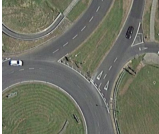
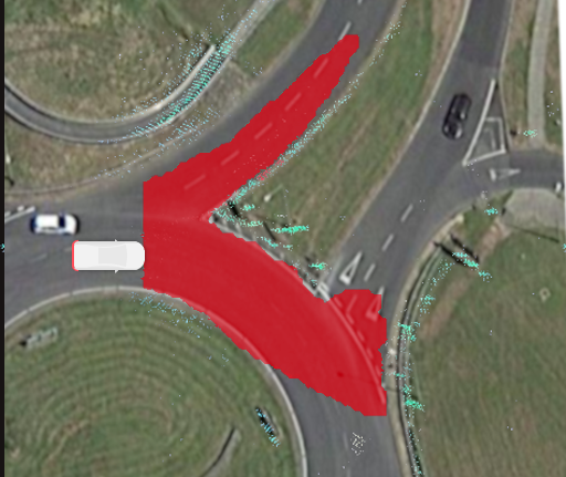
Drag the divider on the right to compare a real radar-derived freespace polygon against satellite imagery for the same roundabout. The polygon traces the diverging road and the exit purely from accumulated radar reflections — no HD map, no GNSS, no camera input — and follows the curve where lane-following methods would fail. The same approach was demonstrated live at CES 2024 and is described in Provizio’s whitepaper ‘Accurately constructing free space maps using radar only’.
- Polygon derived from radar reflections alone — no HD map, no GNSS, no camera
- Demonstrated live at CES 2024 with on-vehicle imaging radar
- Patented mapping method (granted)
- Detects freespace beyond line of sight — around the next bend or roundabout exit
 + FREESPACE POLYGON
Integration
Designed to plug into your perception stack.
Radar Freespace distills the occupancy grid into a clean, drivable 2D polygon, so downstream path planners can consume it directly without per-cell interpretation. The polygon is published alongside the rest of the 5D Perception stream over standard automotive networking.
- Computationally efficient
- Outputs a single drivable-area polygon
- Patented approach
Questions, answered
Radar Freespace FAQ
A 2D freespace polygon — a clean geometric boundary delineating the area that's safe to drive. Path planners can consume this directly without needing to interpret a dense occupancy grid. That keeps the computational cost downstream of perception low.
Ray tracing only identifies space in front of detected objects, leaving shadow gaps behind them. Grid mapping is good at object boundaries but unreliable at interior free areas. Provizio Freespace mapping identifies the complete connected freespace — including areas beyond line-of-sight, like the other side of a roundabout — and makes no assumptions about road structure.
Camera freespace is distorted by inaccurate range measurement, and fails in fog, smoke, dust, darkness and direct sunlight. Radar maintains range accuracy and stays operational across all those conditions. Even on camera-primary platforms, Radar Freespace is the complementary all-weather safety layer with extended range.
All-weather freespace, on the edge.
If your autonomous system needs a freespace boundary that's robust in fog, smoke and darkness — Radar Freespace is the patented method for it.