
Radar Odometry
Every autonomy task depends on knowing where the vehicle is and how it’s moving. GPS works in the open. Underground, in tunnels, in multi-storey car parks, in dense urban canyons — it doesn’t. Radar Odometry extracts ego-motion directly from the radar point cloud: vehicle velocity, yaw rate, heading. No satellites, no wheel encoders, no cameras. The same sensor that’s already perceiving the scene is now positioning the vehicle.
0
satellites required
All-weather
fog, dust, darkness
On-edge
runs on the radar’s SoC
Applications
Where GPS stops working — and autonomy still has to.
Mining
Underground haulage vehicles, autonomous loaders and personnel-safety systems operating where no GNSS signal reaches. Radar Odometry provides continuous positioning using only the radar point cloud.
Tunnels
Highway tunnels, rail tunnels, indoor logistics corridors. GNSS drops the moment you cross the threshold; Radar Odometry continues uninterrupted at the same frame rate.
Car parks
Automated parking systems in multi-storey concrete structures. No satellite signal, lighting varies from dark to bright — radar’s environmental immunity makes Radar Odometry the positioning backbone.
Urban canyons
Tall-building corridors where GNSS multipath errors can be several metres. Radar Odometry provides drift-corrected positioning that doesn’t depend on overhead satellite visibility.
How it works
Ego-motion from the same radar that’s perceiving the scene.
STEP 01
See what isn’t moving
The radar sees thousands of points each frame. Many of them — buildings, road surface, signs, walls — belong to things that aren’t moving. As the vehicle drives, every one of those stationary points appears to move at the same relative rate. That shared motion is the vehicle’s own motion, viewed from the radar’s perspective.
STEP 02
Solve for the vehicle’s motion
Combine the apparent motion of every static point and a single answer falls out: how fast the vehicle is moving, in which direction, and how quickly it is turning. The answer is updated for every radar frame, several times per second.
STEP 03
Build a picture over time
Once we know how the vehicle moves between frames, successive radar scans can be lined up and combined. Sparse single-frame data turns into a dense, map-like view of the surroundings — the foundation for SLAM and the downstream perception stack.
Featured deployment
Demonstrated to ESA, benchmarked against GNSS.
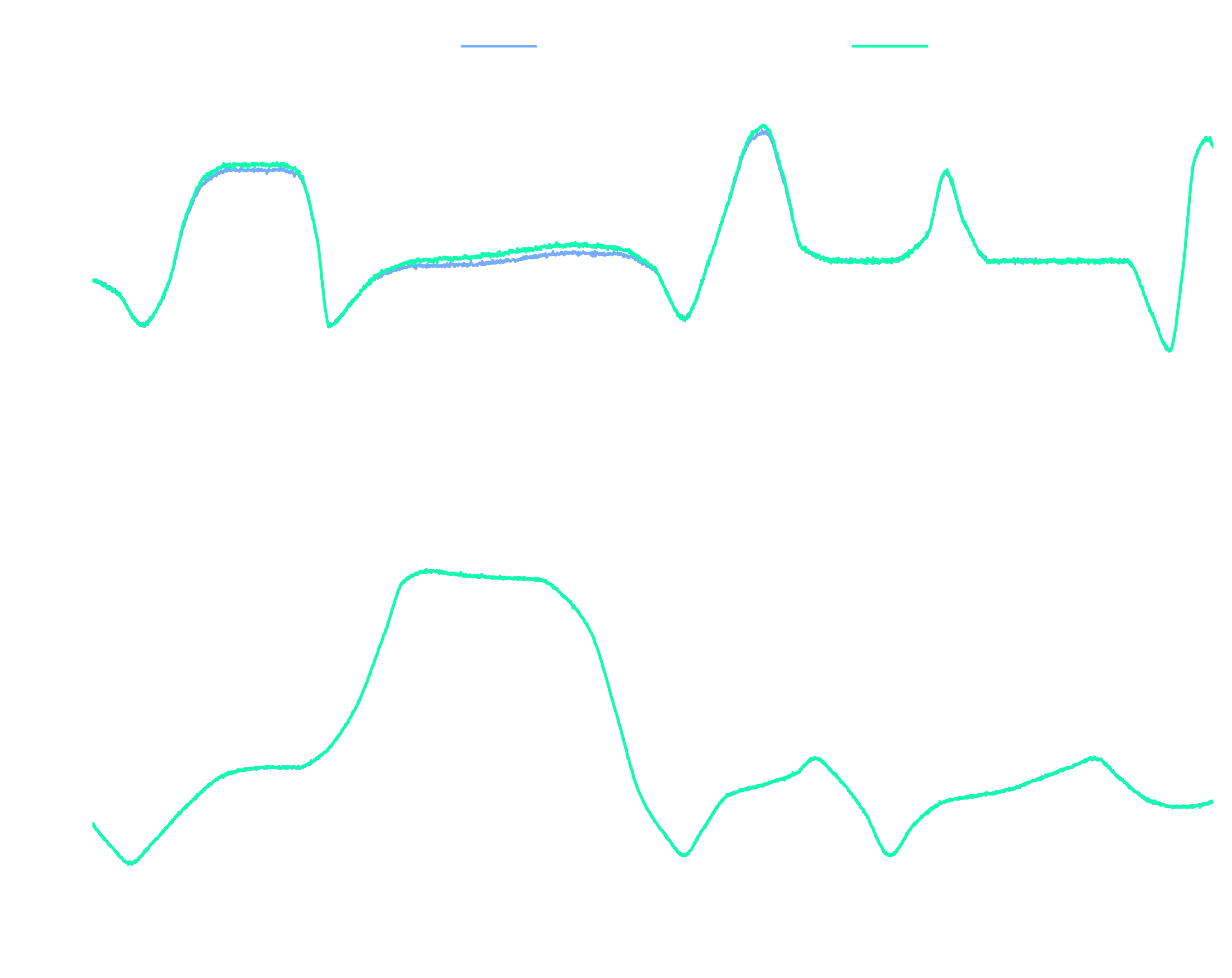
Provizio demonstrated radar odometry to Enterprise Ireland ESA representatives as part of the NAVISP programme — the European Space Agency’s navigation innovation initiative. Internal benchmarking against high-precision GNSS reference data shows very close agreement across motorway, dual-carriageway and urban driving captures.
- Demonstrated to Enterprise Ireland ESA representatives
- Internally benchmarked against high-precision GNSS — close agreement across drive captures
- Automatic radar mounting-angle calibration from odometry data itself
- Deployed on customer units today
Integration
Standalone software — runs on any imaging radar’s SoC
Radar Odometry is delivered as a standalone, licensable software module. It runs on the embedded SoC of any compatible imaging radar and publishes velocity, yaw rate and heading via DDS. Drop it into any perception stack for a robust positioning backbone.
- Standalone licensable software
- Runs on the radar’s embedded SoC
- DDS output (vx, vy, yaw rate, heading)
- Hardware-agnostic — feeds any perception stack
- Open-source C++ and Python APIs
Questions, answered
Radar Odometry FAQ
GNSS depends on satellite signals reaching the receiver, which fails underground, in tunnels, in multi-storey car parks and indoors. Radar Odometry uses only the radar’s own measurements of its surroundings to compute the vehicle’s motion. Where GNSS gives you several-metre errors in urban canyons through multipath, Radar Odometry maintains accuracy because it doesn’t rely on overhead satellite visibility at all.
Internal benchmarking shows close agreement with high-precision GNSS reference data across motorway, dual-carriageway and urban driving captures. We compare radar-derived velocity and yaw-rate traces against GNSS-derived ground truth and the curves track each other tightly. The system was demonstrated to ESA representatives as part of the NAVISP programme.
No. Radar Odometry uses only the radar point cloud and its Doppler-velocity information. That’s what makes it work in conditions that defeat optical sensors — darkness, fog, smoke, dust. It can be fused with IMU, wheel-encoder or GNSS data downstream if needed, but the core algorithm is radar-only.
On the radar’s embedded SoC. Output (velocity, yaw rate, heading) publishes via DDS at the radar’s frame rate. Customers can consume it through Provizio’s open-source C++ and Python APIs.
Localisation where GPS can’t reach.
If your autonomous platform operates in mines, tunnels, car parks, indoor environments — anywhere GNSS isn’t reliable — Radar Odometry provides the positioning backbone, using the radar you already have.